
CENTENNIAL, Colo. — Vexcel has completed a wide-scale, multi-day aerial imagery collection in response to Hurricane Milton, covering nearly 20% of Florida. As part of its post-disaster Gray Sky Program, the collection includes high-resolution ortho and multispectral imagery across all areas, with oblique imagery captured in select urban locations.
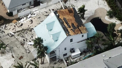
Every property in the Hurricane Milton Gray Sky collection features a comprehensive damage assessment along with timestamped before-and-after imagery for comparison. This enables insurers, emergency managers, and government agencies to assess the storm’s impact with greater efficiency. The collection spans more than 33,000 square kilometers—approximately 20% of Florida—helping response and recovery needs. Across this collection, nearly 4.43 million structures were analyzed for damage.
Areas Captured
Key cities in the Florida collection include: Anna Maria, Bradenton, Clearwater, Daytona Beach, Fort Meade, Fort Myers, Homosassa Springs, Kissimmee, Lakeland, Largo, Longboat Key, Melbourne, Naples, Orlando, Port St. Lucie, Sarasota, Sebring, Siesta Key, Spring Hill, St. Petersburg, Tampa, and Town ‘n’ Country.
Swift Response to Collect Imagery
Hurricane Milton made landfall as a Category 3 storm on October 9. Within 16 hours, Vexcel mobilized its first fleet of aircraft to begin collecting imagery. Over the next eight days, and as weather conditions permitted, up to nine fixed-wing aircraft were deployed daily to capture high-resolution ortho and multispectral imagery in areas affected by hurricane-force winds and tornadoes. Oblique imagery was also captured in key cities and urban areas.
Throughout the collection process, imagery was processed and released in waves to customers and partners. This imagery is all available through the Vexcel Platform and on select partner websites.
Comparing Hurricane Impacts Over Time
Vexcel’s ongoing collection programs across Florida enable before-and-after comparisons, helping stakeholders visualize the full extent of storm damage. Some areas within the Milton Gray Sky collection also feature imagery from previous hurricanes, including Hurricane Ian in 2022, offering valuable insights that span multiple years.
Just days before Hurricane Milton, Vexcel collected imagery from areas affected by Hurricane Helene across five states—Florida, Georgia, North Carolina, South Carolina, and Tennessee. As part of its Gray Sky Program, Vexcel, along with its sister brand, the Geospatial Insurance Consortium (GIC), captures high-resolution aerial imagery of properties impacted by hurricanes, wildfires, and tornadoes.
Learn More
View sample imagery from Hurricane Milton and explore more about Vexcel’s and GIC’s disaster response efforts at: https://gic.org/gray-sky-hurricane-milton/
About Vexcel
For over 30 years, Vexcel has been the industry leader in the photogrammetric and remote sensing space, building market-leading UltraCam sensors and providing a comprehensive library of cloud-based geospatial data. The Vexcel Data Program is the largest aerial imagery program in the world, collecting high-resolution imagery and geospatial data in 40+ countries. Its dedicated fleet of fixed-wing aircraft captures imagery in the U.S., UK, Canada, Australia, New Zealand, Japan, and across Western Europe. Vexcel’s unique technology stack results in consistency across its aerial collection programs. Its comprehensive aerial data library helps customers streamline remote assessment, innovate common workflows, and enhance decision-making with confidence. More at: vexceldata.com
SOURCE Vexcel Data Program
