Vaughan, Ontario, CANADA – September 10, 2024 — Teledyne Geospatial will display their robust portfolio of solutions for inspection, maritime, and mapping applications at INTERGEO 2024, Stuttgart, Germany, September 24-26, 2024. Visit Hall 1, Stand D1. 002 to learn how Teledyne’s integration of industry-leading hardware and software workflows results in unmatched comprehensive solutions for real-time mapping insights.
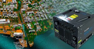
Teledyne Geospatial will showcase its new airborne lidar solution Galaxy Edge, featuring parallel scan lines, with real-time processing and control providing the ability to go direct from plane to production. Also showcased will be Network Surveyor—a tailor-made solution for utilities that features Optech lidar with edge-processing utilizing Galaxy Onboard, enabling actionable insights in hours not weeks.
Teledyne Geospatial will also feature exciting new products launches at this year’s INTERGEO. Visit the exhibit to learn about new products ranging from the smallest lidar to new solutions for bathymetry.
Teledyne Marine will be present at the stand ready to showcase how marine technologies can solve subsea challenges. Also hear from our team how critical business decisions are enabled using Teledyne FLIR IIS’s Ladybug6 spherical camera, which delivers the highest quality and spatial accuracy in 360-degree imaging.
Teledyne Geospatial unifies the hardware and software expertise of both Teledyne CARIS and Teledyne Optech. The new group provides customers with innovative integrated solutions. Offerings include turnkey systems, lidar and sonar integrated workflows and a range of systems and solutions that support holistic, precision data collection.
