Airbus Defence and Space and 3v Geomatics have extended their multi-year agreement to continue to provide Synthetic Aperture Radar (SAR) imagery acquired by the TerraSAR-X/TanDEM-X and PAZ satellites. Airbus’ Radar Constellation acquires the largest range of high-resolution data to wide area coverage, with acquisition modes providing data with spatial resolutions from 25cm to 40m, completely independent of lighting and weather conditions.
This multi-year extension will provide 3v Geomatics with the ability to order new imagery acquisitions over any location on the globe as well as archive data to support Interferometric (InSAR) analysis of ground surface motion. Airbus’ unique radar capabilities facilitate the application of interferometry on a global scale, enabling detailed and widespread monitoring with millimeter precision.
“We are thrilled to continue to support 3v Geomatics with readily available, high-quality precise radar data to support the needs of their customers,” said Nicolas Stussi, Managing Director of the North America geospatial division of Airbus Defence and Space. “3v Geomatics will use this data to continue enabling their customers to manage risk, by providing early warnings and delivering other actionable intelligence over areas quickly and efficiently.”
“By extending our agreement with Airbus, we can continue to access high quality SAR data and provide our customers with state of the art InSAR monitoring programs” – Adrian McCardle, President 3v Geomatics.
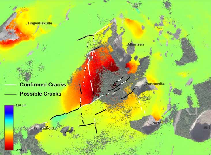
Radar imagery from Airbus delivers very precise and accurate imagery, especially for applications where Interferometry is needed, due to the formation of the satellites. The imagery can be collected over the same location and with the same geometry but at different times allowing analysts with the ability to measure displacement of the Earth’s surface. InSAR can be used to monitor areas hit by Earthquake, landslides, infrastructure monitoring, urban subsidence, mining activities and much more.
Learn more about the imagery and radar capabilities from Airbus, as well as how 3v Geomatics can help monitor and mitigate risk.
Radar imagery from Airbus combined with InSAR analysis from 3v Geomatics shows displacement rates with and without crack data annotations over Malmberget Mine, Sweden.