
GIS-based toolkit can predict risks of erosion and landslides for highways, railroads, pipelines, electric transmission, and more
NORWOOD, Mass.-For owners and operators of complex networks of horizontal infrastructure such as highways, railroads, and powerlines and pipelines, a major challenge today is predicting and cost-effectively deploying preventive maintenance dollars towards the areas of their systems at higher risk from soil erosion and landslides.
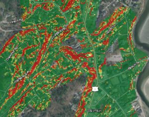
INFRASTRUCTURE PROTECTION TOOL: This screen grab from a new award-winning GZA GeoEnvironmental Inc. GeoTool powered by ArcGIS shows how the software platform can quickly identify “high hazard areas” vulnerable to erosion and landslides. Suitable for use by a wide range of horizontal infrastructure managers, including highway agencies, railroads, pipeline and powerline operators, and others, the “Erosion-Slope Stability Toolkit” was originally developed by GZA for the Maine Department of Transportation and New England Transportation Consortium (NETC) and recently won top honors from the American Council of Engineering Companies. (Graphic: Business Wire)
GZA GeoEnvironmental, Inc. (GZA), a leading multi-disciplinary firm providing geotechnical, environmental, ecological, water, and construction management services, recently received major engineering awards from the American Council of Engineering Companies (ACEC) and ACEC of Maine for its “Erosion-Slope Stability Toolkit” that directly addresses this critical need for infrastructure managers in a cost-effective, easy-to-use way.
Originally developed for the Maine Department of Transportation and New England Transportation Consortium (NETC), the toolkit evaluates enormous Geographic Information Systems (GIS) data sets including topography, land use, surficial geology, and floodplains to identify infrastructure segments at higher risk of soil erosion or landslides.
GZA President and CEO Patrick Sheehan said: “Transportation and energy leaders face extraordinary challenges today to protect their infrastructure from a wide range of threats, including extreme weather and the impacts of climate change. The GZA Erosion/Slope Stability Toolkit offers an innovative, cost-effective solution for managers to identify the segments of their networks potentially at higher risk to erosion and landslides specifically so they can best prioritize preventative maintenance investment.”
The prototype ESRI ArcGIS toolkit developed for the Maine DOT has also been used with NETC to develop a multi-scale, multi-season land-based erosion and landslide modeling and monitoring toolkit for the five other New England states: Connecticut, Massachusetts, New Hampshire, Rhode Island, and Vermont. The same principles and techniques used to apply the Maine prototype to other states’ highways can be applied in other jurisdictions and for all kinds of horizontal infrastructure including fire roads in forests critical to providing access to firefighting crews.
In a letter to ACEC nominating GZA for the award, the Maine DOT noted that the toolkit has “a user-friendly ESRI GIS interface” that “provide[s] easy access to identify, monitor, and forecast roadway sections vulnerable to erosion and instability … [and] allows easy navigation of a large area and screening for slope/erosion issues without performing complex numerical modeling or calculations.’’
Leading the ongoing development of the toolkit for GZA have been Bin Wang, Aimee Mountain, Daniel Stapleton, and Christopher Snow. Wang is a Senior Technical Specialist and civil and water resources engineer at GZA. Mountain is a Senior Project Manager who specializes in data management, spatial analysis, and development of GIS-based asset management and environmental assessment systems. Stapleton, now retired from GZA, was a Senior Principal and Senior Vice President at who headed up GZA’s Natural Hazard Risk Management, Climate Adaptation, and Resilience services. Snow is a Principal and Vice President who manages GZA’s Portland office.
GZA received an ACEC National Recognition Award and an ACEC Maine Grand Conceptor Award for the toolkit earlier this spring.
About GZA
GZA is a multi-disciplinary, employee-owned firm providing Geotechnical, Environmental, Ecological, Water, and Construction Management services. GZA’s more than 700 professionals are based in 32 offices across the United States. Our corporate headquarters is at 249 Vanderbilt Avenue, Norwood, Mass. 02062.
