Montreal, Canada — Presagis, a global leader in 3D advanced modelling and simulation software, is releasing the 3D Environments Add-In application for Esri’s ArcGIS Pro. 3D Environments allows ArcGIS users to rapidly transform 3D Tiles Next data formats, such as One World Terrain, into ArcGIS Pro projects to create 3D scenes from 2D vector data and 3D models.
The 3D Environments Add-In for ArcGIS Pro lets users convert 3D Tiles data into i3S files while preserving domain schemas, such as the One World Terrain (OWT) Ground-Warfighter Geospatial Data Model (GGDM).
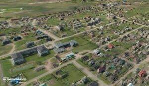
Available on the Esri ArcGIS Marketplace at the end of June, the 3D Environments Add-In leverages Presagis’ building templates and texture libraries that analysts can use to create enhanced 3D visualizations of GIS environments, thus helping increase collaboration across the enterprise. The Presagis 3D Environments Add-In contains tools to create, transform, and extract a wide variety of 3D formats to provide seamless interoperability between ArcGIS Pro and modeling & simulation applications.
“The 3D Environments Add-In is the result of the close relationship we have built with Esri. We are excited to bring our modelling and simulation expertise to the Esri Marketplace and the ArcGIS community,” said Jean-Michel Briere, President of Presagis, “the convergence of GIS data and simulation is critical to create accurate and realistic digital twins – and Presagis can help lead the way.”
“The Presagis 3D Environments Add-in for ArcGIS Pro extends 3D workflow interoperability between ArcGIS and ModSim 3D data formats such as CDB,” said Jamon Johnson, Product Leader for the Esri 3D Core Team. “Analysts can now fully integrate CDB into their ArcGIS Pro projects as well as leverage OpenFlight Models into 3D visualization applications.”
The ability to create and implement detailed and realistic 3D content in ArcGIS Pro is available now. To learn more and sign up for a 30-day free trial, please visit:
https://www.presagis.com/en/product/3denvironments-addin/
or, visit the Esri ArcGIS Marketplace.
About Esri
Esri, the global market leader in geographic information system (GIS) software, location intelligence, and mapping, helps customers unlock the full potential of data to improve operational and business results. Founded in 1969 in Redlands, California, USA, Esri software is deployed in more than 350,000 organizations globally and in over 200,000 institutions in the Americas, Asia and the Pacific, Europe, Africa, and the Middle East, including Fortune 500 companies, government agencies, nonprofits, and universities. Esri has regional offices, international distributors, and partners providing local support in over 100 countries on six continents. With its pioneering commitment to geospatial information technology, Esri engineers the most innovative solutions for digital transformation, the Internet of Things (IoT), and advanced analytics. Visit us at esri.com.
About Presagis: Presagis is a global leader providing commercial modeling, simulation and embedded software solutions to the aerospace, defense, security, and critical infrastructure markets. Presagis combines an open simulation development framework with expert professional services to help customers build vast dynamic virtual environments, deliver game-quality immersive simulations – all the while streamlining workflows and reducing risks. Presagis is also at the forefront of avionics software design for certifiable cockpit displays, and, together with its modeling and simulation offerings, serves hundreds of customers worldwide, including many of the world’s most respected organizations such as Boeing, Lockheed Martin, Airbus, BAE Systems, and CAE. For more information, visit www.presagis.com.
