
These patented technologies enable a multispectral, multichannel, topo-bathy lidar system to fly higher and collect more data in less time than previous systems.
DAYTON, Ohio (Jan. 10, 2022) — Woolpert has been granted a patent by the United States Patent and Trademark Office for its “Airborne Topo-Bathy Lidar System and Methods Thereof.” A lidar sensor system was developed by a multidisciplinary research and development team incorporating these technologies that enable the collection of high-resolution topographic and bathymetric data at a higher altitude, resulting in a broader swath than previously developed lidar systems.
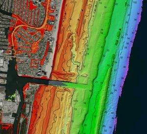
Woolpert collected high-altitude bathymetric lidar data from 3,048 meters, or 10,000 feet, over Fort Lauderdale, Fla., in 2021 via newly patented technology incorporated into the BULLDOG sensor. The data measured depths in excess of 55 meters. This image notes the range of depths in soundings and contours, courtesy of NOAA’s Electronic Navigational Charts map service. Image courtesy of USACE/JALBTCX
“Commercially available airborne lidar bathymetry systems currently operate at low altitudes, which are far below the altitudes of topographic lidar systems,” Woolpert Lead Scientist Nathan Hopper said. “Increasing the operational altitude of airborne lidar bathymetry systems to 10,000 feet presented several challenges that required novel approaches. This patent covers the proprietary technology developed to overcome the many challenges associated with high-altitude topography and bathymetry.”
The patent applies to the technologies that enable the lidar system’s optical design, hybrid detector approaches and field of view management. For instance, reformatting hardware was invented to allow for the illumination of a full detector array, increasing the probability of detection. Hopper said the team’s primary design focus was maximizing the use of three wavelengths of light—532, 647 and 1,064 nanometers—by distributing them into distinct detector channels designed for shallow water, deep water, Raman and topo. The infrared light is further split into a linear mode and Geiger-mode channel explicitly utilized for sea surface and topographic measurements. This hybrid approach coupled with reformatting capabilities supports increased spatial resolution and reduces vertical biases.
These technologies were borne out a need to equip the U.S. Army Corps of Engineers with the capability to collect greater detail over larger areas, as well as a providing a more efficient, safer and cost-effective means of doing so. The research that went into the development of these technologies will not only support future sensor development efforts but will enable more efficient data collections for the Joint Airborne Lidar Bathymetry Technical Center of Expertise (JALBTCX), its partner organizations and Woolpert’s commercial clients. Coastline data from oceans, lakes and other waterways helps track erosion, monitor the environmental impact of natural disasters, perform volumetric studies, support sediment management, ensure safe navigation and port security, and drive economic development.
Woolpert began providing geospatial services in 1969 and conducted its first countywide topographic lidar data collection in 2000. The firm has collected more than 3 million square miles of lidar and imagery, owns and operates a fleet of aircraft and sensors, and has been contracted to test emerging lidar technologies and the development of lidar sensor systems.
The firm established a research and development lab in Bay St. Louis, Miss., assembled a team of engineers and scientists, and developed a high-altitude topo-bathy lidar sensor system incorporating these patented technologies, the Bathymetric Unmanned Littoral LiDar for Operational GEOINT (BULLDOG).
About Woolpert
Woolpert is the premier architecture, engineering, geospatial (AEG), and strategic consulting firm, with a vision to become one of the best companies in the world. We innovate within and across markets to effectively serve public, private, and government clients worldwide. Woolpert is an ENR Top 150 Global Design Firm, recently earned its sixth-straight Great Place to Work certification, and actively nurtures a culture of growth, inclusion, diversity, and respect. Founded in 1911 in Dayton, Ohio, Woolpert has been America’s fastest-growing AEG firm since 2015. The firm has more than 1,600 employees and 60 offices on four continents. For more, visit woolpert.com
