
Lausanne, Switzerland, [April 27, 2021]: Pix4D, the industry leader in photogrammetry, announces today the commercialization and worldwide exclusive distribution of the viDoc RTK rover, enabling ground-based RTK-grade 3D scanning with iOS mobile phones and tablets through the Pix4Dcatch app.
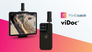
Conceived by viGram GmbH., a German company led by professional surveyors, the viDoc RTK rover is designed with an eye for accuracy and works with Pix4Dcatch for image acquisition. The hand-held RTK rover is a replacement for more expensive ground surveying equipment that does not compromise on accuracy to achieve 3D, actionable results.
The viDoc RTK rover, synchronized with Pix4Dcatch, geotags the images of a 3D scan in real-time, while connected to any NTRIP service. Extensive research has revealed that it is possible to achieve 3D models with an absolute geolocation accuracy of less than 5 cm (check the white paper here).
Christoph Strecha, Founder and CEO of Pix4D, comments: “We are happy to see how Pix4D algorithms complement consumer tech to achieve professional-grade results. This was the case with drones a few years back. Now it’s the turn of mobile devices, allowing professionals to digitize the world and turn it into accurate 3D models at a fraction of the price. The new solution combines RTK accurate image tagging with photogrammetry and LiDAR (for LiDAR enabled mobile devices) processing.”
The viDoc RTK rover for Pix4Dcatch is available today for shipping to Europe. It is available for the rest of the world starting from May 20, directly through Pix4D or our resellers.
Pix4Dcatch is free to download on the App Store.
About Pix4D
Pix4D (pix4d.com) develops cutting-edge software that converts images taken by hand, drone, or plane into accurate and georeferenced survey-grade 2D mosaics, 3D models, and point clouds. Founded in 2011, Pix4D is rapidly expanding from its headquarters in Lausanne, Switzerland, to offices in Berlin, Madrid, Denver, San Francisco, Shanghai, and Tokyo.
