
BERLIN, Germany – UP42 is pleased to announce that the NEXTMap Elevation Data Suite from Intermap Technologies is now offered on the UP42 developer platform for Earth observation data and analytics. The NEXTMap 3D elevation products are available as Digital Surface Models (DSM) and Digital Terrain Models (DTM) at one-, five-, and 10-meter resolution.
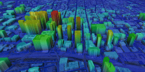
NEXTMap Digital Surface Model (DSM)
The addition of NEXTMap datasets to the UP42 marketplace enables users to build even more powerful geospatial solutions in the areas of infrastructure management, construction planning, geologic mapping, land cover classification, forestry, resource conservation, and contour generation.
“We are excited to add NEXTMap elevation models to the UP42 platform. Our customers need this data for a range of use cases, including monitoring of vital infrastructure projects such as pipelines, powerlines and railway corridors,” said UP42 CEO Sean Wiid. “High-quality 3D data is critical in every phase of infrastructure management from construction planning to ongoing monitoring of vegetation encroachment.”
UP42 gives users direct access to extensive Earth observation datasets and advanced processing algorithms – along with cloud computing power – to create their own geospatial solutions easily and inexpensively. Users purchase just the data needed to cover their area of interest and then leverage scalable processing capabilities to analyze the datasets without investment in their own computing infrastructure.
Based in Englewood, Colorado, Intermap Technologies is a provider of geospatial datasets, solutions, and software. The NEXTMap 3D products are seamless digital elevation models derived from satellite imagery and are available worldwide. The NEXTMap DSMs deliver rich feature content, including vegetation, building structures and roads. The DTMs are bare-earth elevation models from which surface features have been removed.
Three NEXTMap digital elevation datasets are now available from UP42:
· NEXTMap One with 1m spatial resolution, 1m vertical and 3.5m horizontal accuracy.
· NEXTMap 5 with 5m resolution and 1.6m vertical and 3.5m horizontal accuracy.
· NEXTMap 10 with 10m resolution and 8.4m vertical and 17.5m horizontal accuracy.
“Our goal at UP42 is to create a single platform where our users have access to all the geospatial data, analytics and processing infrastructure they need to build solutions that solve critical real world problems,” said UP42’s Wiid. “Intermap’s NEXTMap elevation models dramatically expand our core data offering and, as a result, expand the range of use cases we can help our customers address.”
Ivan Maddox, EVP at Intermap Technologies states, “We are excited to be working with UP42. They are one of the key players in the future of geospatial analytics we are building. This collaboration shows the importance of combining global datasets with cutting-edge analytics.”
The NEXTMap datasets join a variety of Earth observation information already on the UP42 marketplace, including Pleiades 1A/B, SPOT 6/7, Landsat-8, TerraSar-X, Sentinel-2 and MODIS satellite imagery, Getmapping U.K. aerial data, exactEarth AIS data, and Meteomatics weather and ocean data. Leveraging these datasets, users may apply more than 50 geospatial analytics processes, including machine learning algorithms, to automatically find features, count objects, detect change, uncover patterns, classify land use, and derive vegetative indices.
For more information on UP42 Earth observation datasets and processing algorithms, visit https://up42.com/goingup/high-resolution-elevation-data/.
About UP42
UP42 is changing the way geospatial data is accessed and analyzed. The platform and marketplace bring together multiple sources of data such as satellite imagery, weather data, and more—together with algorithms to identify objects, detect change, and find patterns. Industry leaders use UP42 to inform business decisions and build scalable customer solutions. Know when and where to fertilize crops. Measure air quality and map emissions. Count cars, trucks, planes, and ships. Developers and data scientists across all industries now have access to a platform to build, run, and scale projects in one place. Visit www.up42.com.
