
Program Open to Cost-Sharing Partners
DENVER, Colorado – VeriDaaS Corp., a leading geospatial solutions company, is planning a high-density LiDAR elevation data collection at a minimum of 30 points per meter (ppm) over the entire State of California in the Spring 2021 as part of the VeriDaaS National Mapping Initiative (VeriMAP™). Higher density data above 30 ppm is also an option if stakeholder commitments are secured before the planned start of the project.
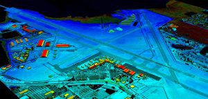
Colorized digital elevation model of International Airport in Pinellas County, Florida.
The geospatial data will be utilized across a wide range of private-sector vertical markets including electric utilities, transportation, telecom, insurance, and architecture/engineering/construction (AEC), as well as Federal, State and Local Government groups. The California VeriMAP™ program is open to new participants. Private- and public-sector organizations that wish to participate as stakeholders purchasing high-density LiDAR elevation data sets at reduced cost-sharing rates should contact VeriDaaS now.
VeriDaaS will be using the Geiger-mode LiDAR sensor systems and multiple fixed-wing aircraft for the project. The Geiger-mode sensors are optimized for highly efficient collection of high-density data from higher altitudes while maintaining precision and accuracy over wide geographic areas. The elevation data collected will then be processed and classified to generate derived products and analytical information to support decision-makers across multiple vertical markets. VeriDaaS and its partner network will generate the derived products to meet the specific needs of the users in each targeted vertical market.
“We are pleased to announce this Statewide California mapping project that will support a wide-range of uses cases for both commercial and government customers,” said Christopher Payne, CEO of VeriDaaS. “We are currently building a coalition of multiple stakeholders to support the funding of the project. This will significantly lower the cost for all customers and maximize the return-on-investment and value.”
He added, “This project aligns with our VeriMAP™ program to build national, scalable repositories of high-density data that is commercially available for a wide range of customers on demand.”
A high percentage of the current LiDAR data coverage for the U.S. is at the USGS-defined QL2 or 2 ppm density level. While this density supports a few high value use cases, there are significant advantages and a wider range of use cases that can be realized with higher density data. Additionally, there are large-area gaps in the current U.S. coverage, as well as data legacy issues, that diminish the value of existing data.
The VeriMAP™ offering is addressing the market demands for timely, higher density data solutions for a broader customer base with discriminating sensor technology, high-quality technology partners and stakeholder collaboration. Interested stakeholders can contact VeriDaaS to learn more about participation in this project. Please contact Conse Vecchio at [email protected] for additional information.
About VeriDaaS
VeriDaaS is a Denver-based leading geospatial solutions provider focused on providing data, products, and actionable information, at a national level across a wide-range of vertical markets. Visit https://veridaas.com.
