
BERLIN, Germany – High-resolution aerial imagery from the HxGN Content Program is now available on the UP42 developer platform for Earth observation data and analytics. UP42 customers may now choose from nearly 11 million square kilometers of 30 cm orthorectified imagery for North America and Europe and over 500,000 sq km of 15 cm data for major U.S. cities in the Hexagon aerial image library.
UP42 gives users direct access to extensive Earth observation data sets and advanced processing algorithms – along with cloud computing power – to create their own geospatial solutions easily and inexpensively. The platform provides all the tools UP42 customers need to develop geospatial workflows, applications, and even commercial products.
“The HxGN Content Program is a valuable addition to the UP42 marketplace because it is an extremely vast library of orthorectified aerial imagery available for Europe and North America,” said UP42 CEO Sean Wiid. “This data can be accessed within the UP42 console or via API, where it can be downloaded, processed, or integrated into geospatial products.”
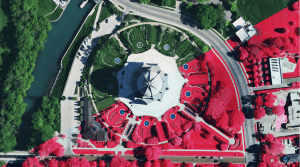
Managed by Hexagon, a global leader in sensors, software, and autonomous solutions, the HxGN Content Program has created an archive of cloud-free, four-band (Red, Green, Blue, Near IR) multispectral data acquired in the past two years with Leica ADS100 and DMC III airborne sensors. The data sets have been orthorectified to deliver the highest level of positional accuracy and consistency – regardless of geographic area. The library is updated every two to three years.
“We are very pleased to partner with UP42. The UP42 platform will leverage the entire US and European HxGN Content Program data libraries to create analytics that will help customers solve problems faster,” says Katie Fitzsimmons, Reseller Manager at Hexagon. “The UP42 platform allows customers easy ways to create insights that inform business decisions. We look forward to an exciting collaboration.”
With its exceptional positional accuracy, HxGN Content Program data sets are used extensively as GIS base maps and in applications ranging from infrastructure management, agriculture, insurance, real estate, forestry, and many others. The extraordinary data consistency over large areas has made Hexagon’s orthoimages ideal for use as training data sets in machine learning and artificial intelligence projects.
“Hexagon’s aerial imagery complements the wide variety of remote sensing data sets currently in the UP42 marketplace,” said UP42’s Wiid. “These data sets are available alongside an array of powerful pre-processing, statistical, band math, and machine-learning algorithms that solve critical real-world problems.”
The HxGN Content Program data sets join a broad selection of Earth observation information already on the UP42 marketplace, including Pleiades 1A/B, SPOT 6/7, Landsat-8, TerraSar-X, Sentinel-2, and MODIS satellite imagery, Getmapping U.K. aerial data, and Meteomatics weather and ocean data.
UP42 users may apply more than 50 geospatial analytics processes, including machine learning algorithms, to automatically find features, count objects, detect change, uncover patterns, classify land use, and derive vegetative indices from remote sensing data sets.
Read more about the partnership and the HxGN Content Program data sets on the UP42 website.
UP42 is changing the way geospatial data is accessed and analyzed. The platform and marketplace bring together multiple sources of data such as satellite imagery, aerial data, weather data, and more—together with algorithms to identify objects, detect change, and find patterns. Industry leaders use UP42 to inform business decisions and build scalable customer solutions. Know when and where to fertilize crops. Measure air quality and map emissions. Count cars, trucks, planes, and ships. Developers and data scientists across all industries now have access to a platform to build, run, and scale projects in one place. Visit www.up42.com.
