
Rome, NY- Microdrones has enjoyed a strong spring “growing season” with the launch of the popular Microdrones as a Service (mdaaS) business model as well as next generation system features. The company continues to innovate and deliver new technology, diving into the summer months with the launch of four new survey equipment systems.
“Customers have been looking for ways to acquire 3D and Oblique imagery data, and we wanted to offer fully integrated systems, software, workflow, maintenance and support for these applications,” explains Vivien Heriard-Dubreuil, Microdrones CEO. “In addition, we are proud to present a new survey-grade LiDAR system that can capture data from greater flight altitudes, or extremely detailed data from lower altitudes.” Company COO, Frank Darmayan adds “These new systems, combined with our Microdrones as a Service business model, provide a complete technology ecosystem and product lineup that customers can adopt, adapt, upgrade and grow with.”
First up, the company offers fully integrated survey equipment systems for high wall mapping and 3D modeling applications.
mdMapper3000DµoG 3D aaS fills a niche where traditional manned aircraft 3D mapping can’t get close enough to the subject to get the exacting detail for high-end 3D models or high wall mapping. Vice President of Sales for Microdrones, Vincent Legrand says, “Customers will capture all angles and surfaces via an array of five cameras with dual IMU direct georeferencing, all integrated into the processing workflow in mdInfinity software.”
Legrand adds, “mdMapper1000DG 3D aaS provides similar 3D and high wall mapping functionality, but with single IMU direct georeferencing and a smaller drone, to expand the addressable market with a popular price point.”
The newly released mdMapper3000DµoG Oblique aaS adds a fully integrated gimbal to the popular dual IMU direct georeferencing mdMapper3000Dµog system. This provides more opportunity to capture oblique imagery, helpful for high wall mapping and mining photogrammetry applications.
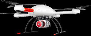
“We are especially excited about the release of our new mdLiDAR3000LR aaS survey equipment,” explains Heriard-Dubreuil, adding “The LR stands for long range; users will extend their data collection reach from high above or use the laser scanning power to collect extreme point density when flying at lower altitudes.”
Legrand concludes, “Demand for our products and mdaaS has been very strong. The b2b surveying, construction and building trades have been busy and eager to adopt new technology that makes them more effective. We’re pleased to have more opportunities and products to meet their demand and continue to lead the market for professional drone applications.”
About Microdrones
Microdrones grew out of the collaboration between the German inventor of the world’s first commercial quadcopter and a determined surveying payload and software developer in North America. The result is a global aerial mapping technology company that delivers complete and reliable mapping systems specifically developed for the surveying, mining, construction, oil & gas and precision agriculture industries. Microdrones Integrated Systems are industrial tools addressing specific complex mapping challenges for professional customers, relying on a fully integrated geospatial workflow that enables cutting-edge software technology from Microdrones to transform raw data collected in the field by Microdrones survey equipment into valuable high-quality survey grade data. Microdrones is widely recognized for its LiDAR technology leadership.
Microdrones has engineering centers and manufacturing facilities in Germany, Canada, France, China and the United States, as well as a sales, support and distribution network spanning six continents. To learn more about Microdrones, visit www.microdrones.com
