
PITTSBURGH, PA – RoadBotics is announcing the addition of Image Logger to its growing suite of products to help communities digitize their assets including roads, sidewalks, trails, and more. This innovative technology places time-stamped geo-spatial image data on a GIS-enabled map, creating an easy way for communities to view all of their public assets on one platform.
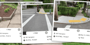
Viewable from a desk or out in the field, Image Logger maps simplify decision making, saving users time and money. “The Image Logger is a great addition to our existing products and tools for road and infrastructure management,” says RoadBotics Head of Product, Matt Lucas. “It helps our clients to better administer their assets while saving valuable resources.”
RoadBotics, known for revolutionary automated pavement assessments made possible by the simplicity of using a smartphone for data collection, has taken their proprietary technology to the next level. With only a smartphone, users can collect data on roads and adjacent assets such as signage and public right of ways including sidewalks, bike trails, and walking paths. Whether collected monthly, seasonally, or before and after maintenance projects, having up-to-date data is invaluable for public infrastructure asset management.
The Image Logger is the first product released on the brand new RoadWay Operating System (OS), a cloud-based online platform. RoadWay OS helps governments manage and administer their public infrastructure asset data in one central location.
“Here at RoadBotics, we understand the needs of our clients and aim to create useful and user-friendly products that support their asset management goals. The Image Logger accomplishes that objective by the ease of use and breadth of data available,” says RoadBotics President and Co-Founder, Benjamin Schmidt, PhD.
The Image Logger was released in early June as the first of many new products that will be introduced on RoadWay OS. RoadBotics is committed to developing technologies to support governments of all sizes in their efforts to maintain community assets efficiently and effectively.
About RoadBotics:
RoadBotics helps governments to better administer their public infrastructure assets by unifying their data onto a single cloud-based platform called RoadWay Operating System (OS). RoadWay OS combines the power of transparency and ability to create data-driven strategies into an infrastructure management tool that saves time and money.
Roadway OS is also available to outside consultants and professionals who help governments do their best work. By providing secure access to both internal and external stakeholders, the maintenance and development of public infrastructure can be greatly improved.
Governments of any size, from small rural communities to state and federal governments, are able to create data-driven strategies using RoadWay OS. Whether they are managing their tactical day-to-day operations or enhancing their strategic planning, the cloud-based features of RoadWay OS can result in taxpayer savings, improved efficiencies, and ultimately, better services for every citizen.
