
Leica Map360 v4.0 introduces three editions to digitize and document any crash or crime scene
(HEERBRUGG, Switzerland) – Leica Geosystems, a Hexagon company, announced today the latest version of Leica Map360 crash and crime scene diagramming and reconstruction software, bringing three editions to meet specific customer needs based on the technology used to measure and collect any scene.
With an entirely new user experience (UX) and interface, Map360 v4.0 simplifies incident reconstruction activities for investigators, reconstructionists and other public safety personnel. With 2D intuitive workflows, Map360 Sketch offers a program designed to create basic diagrams, floorplans and reports from manual measurements, imported points or UAV imagery. At an intermediate level, Map360 Standard works with TPS and GNSS technology introducing 3D capabilities and tools as well as animation. Map360 Pro is directed at those using workflows that result in the creation of a 3D point cloud, such as laser scanners and UAV photogrammetry, offering advanced 3D capabilities and point cloud support.
“This has to be the best release, yet. The majority of our scenes will use the body poser feature to show an accurate reconstruction of the scene,” said Special Agent Scott Kraft of the North Dakota Bureau of Criminal Investigation, a beta test user who provided the product team a full review of the software. “Map360 was a quality product prior to this, but the newest version definitely adds a lot of appeal to the software in terms of ease of use.”
Digitise. Analyse. Present.
Public safety officials can now digitise the narrative, analyse the evidence, and present the facts easier, quicker and more accurately with Map360 v4.0. The critical details of a scene can be visually communicated to judges, juries and other law participants with meticulous diagrams, pre-incident plans, incident reconstructions and other court-ready exhibits with the several new updates in the latest version of the software. Upgraded features include streamlined commands, enhanced properties and grips, interactive objects, increased symbols, body poser, and eight language versions. Other new offerings in the software are an intersection wizard, momentum angle calculator, image scale, points auto connector, QA reports, REGISTER 360 ortho images and geotag support, and silhouette mode.
“Public safety authorities need digital solutions to help protect communities and bring swift and thorough justice,” said Chenel Cordonier, Forensic Product Manager for Leica Map360. “In developing the latest version of Leica Map360, this need was our forethought. We aimed to provide the right software for whatever instrument was used on the scene; ensuring we can support all users in their critically important and essential work. With the new UX, more intuitive workflows, and CAD at the core, all levels of experience and scene complexity can work with Map360 from basic diagramming to advanced point clouds.”
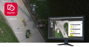
Leica Geosystems, a Hexagon company, announced today the latest version of Leica Map360 crash and crime scene diagramming and reconstruction software, bringing three editions to meet specific customer needs based on the technology used to measure and collect any scene.
Leica Geosystems – when it has to be right
With more than 200 years of history, Leica Geosystems, a Hexagon company, is the trusted supplier of premium sensors, software and services. Delivering value every day to professionals in surveying, construction, infrastructure, mining, mapping and other geospatial content-dependent industries, Leica Geosystems leads the industry with innovative solutions to empower our autonomous future.
Hexagon is a global leader in sensor, software and autonomous solutions. Hexagon (Nasdaq Stockholm: HEXA B) has approximately 20,000 employees in 50 countries and net sales of 3.9bn EUR. Learn more at hexagon.com and follow us @HexagonAB.
