
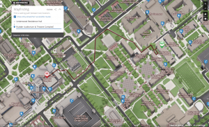
With the new wheelchair accessible route functionality, Concept3D clients are able to offer a separate set of wayfinding routes specifically designed to identify the most efficient and easiest routes.
Concept3D’s wayfinding system uses a weighted algorithm to determine the most efficient route between start and end points, and the new system was enhanced to factor in routing variables like stairs, curb cuts, steep inclines, and other areas that may impact accessibility.
Texas A&M is the first Concept3D client to integrate the new feature into the University’s interactive campus map. While TAMU’s campus terrain is relatively flat, there are a lot of stairs, inclines and curb cuts that may present challenges for campus accessibility and are now factored into the new wayfinding system.
“We created the map with the user in mind,” said Michael Green, Manager of Emerging and Interactive Media at Texas A&M. “We’re especially excited about the new information for wheelchair users. It underscores our reputation for being a welcoming and inclusive community.”
With the updated map, users can now be shown the most direct wheelchair-accessible route and wheelchair accessible entrances, which are not always the main entrances.
“Factoring in the needs of all users has always been important for Concept3D, and we’re proud to continue developing and offering our clients new digital accessibility features,” said Gordon Boyes, CEO of Concept3D. “The wheelchair accessible wayfinding system option is a great feature for higher education, corporate campuses, convention centers, and many other locations using the Concept3D platform.”
For its dedication and consistent initiatives to support digital accessibility, in early 2020 Concept3D earned the coveted title of “Vanguard of Inclusion” from accessibility auditor Level Access.
View images and read more about Concept3D’s wheelchair wayfinding feature at: https://blog.concept3d.com/wayfinding-wheelchair-accessible-routes
Learn more about Texas A&M’s map here: https://today.tamu.edu/2020/01/22/texas-am-adds-wheelchair-accessible-map/
Founded in 2006, Concept3D is a leader in creating immersive online experiences with 3D modeling, interactive maps and VR-enabled virtual tour software. Concept3D software brings any physical location into an intuitive and navigable digital format, providing clients with a powerful competitive edge through applications like data visualization, wayfinding, immersive VR-enabled virtual tours, and real-time platform-wide updates. Concept3D clients include convention centers and event spaces, data centers, healthcare and retirement facilities, large commercial sites, resorts, hotels and theme parks, as well as universities and many other locations. Concept3D’s higher education system was formerly known as CampusBird. Learn more at https://www.concept3D.com.
