
GOLDEN, Colorado – Golden Software, a developer of affordable 2D and 3D scientific modeling packages, today announced that its six software products are now available on GeoCloud, a cloud-based software-as-a-service platform hosting geospatial, mapping, and geoscience applications.
Available 24/7 anywhere in the world, GeoCloud offers pay-per-use and period-subscription access to a variety of popular geospatial software products in the cloud. Rather than download and install the software on their own devices, users create desktops in the cloud where they have access to complete functionality. Their preference settings and data are saved and available from one session to the next.
“GeoCloud provides an opportunity for scientists who need to use Golden Software products for occasional projects to access them inexpensively and only when needed,” said Blakelee Mills, Golden Software CEO. “It also allows users of non-Windows computers to experience the benefits of our applications for the first time.”
“We created GeoCloud to give users instant remote access to licensed software,” said Dr. Yuri Raizman, GeoCloud CEO. “Golden Software products are the first geologic mapping packages on GeoCloud, and our customers will be happy to start using them.”
Already used by more than 100,000 scientific and high-tech clients worldwide, Golden Software products are utilized in environmental consulting, mining, oil & gas exploration and extraction, engineering, geospatial applications, and applied science.
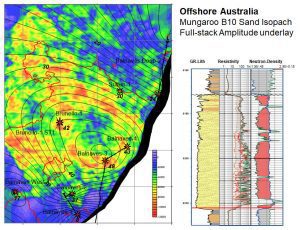
Golden Software products can be used to visualize a variety of data including an isopach map with a full-stack amplitude underlay and a composite log.
The Golden Software products, which are available as a suite on the GeoCloud platform, include the following:
Surfer – A robust data visualization and mapping package, Surfer allows users to model their data sets, apply an array of advanced analytics tools, and graphically communicate the results in ways anyone can understand.
Grapher – Giving users deeper insights into their data, Grapher offers 70 different 2D and 3D graphing tools to plot, analyze and display scientific data.
Voxler – Offering extensive 3D modeling tools, Voxler enables users to easily visualize multi-component data to model geologic features, geophysical surveys, contamination plumes, LiDAR point clouds, boreholes, and ore body deposits.
Strater – Developed for the creation of clear and concise geotechnical reports, Strater eliminates subsurface uncertainty by transforming raw subsurface data into understandable well logs, borehole models, and stratigraphic cross sections and profiles.
MapViewer – Users can quickly and easily create publication-quality maps with extensive thematic mapping and spatial analysis features to spot patterns, trends and relationships in data sets.
Didger – Designed for easier handling of inconsistent data formats, Didger offers digitization, reprojection, tiling, georeferencing and mosaicking functions to transform paper documents into digital formats.
“We put our software products on the GeoCloud platform because we were impressed with their responsiveness in making sure the latest version of each package was available, which guarantees users will have the best experience possible with Golden Software products,” said Mills.
Golden Software products are available now on GeoCloud at www.geocloud.work.
About Golden Software
Founded in 1983, Golden Software is a leading developer of affordable scientific graphics software. Its customer base includes over 100,000 users involved in environmental consulting, oil and gas exploration and extraction, mining exploration and extraction, engineering, applied science, business, education, and government in 186 countries and territories. Golden Software offers six products: Surfer® for gridding, contouring and 3D surface mapping; Voxler® for 3D data visualization; Grapher™ for 2D and 3D graphing; Strater® for well log, borehole and cross section plotting; MapViewer™ for thematic mapping and spatial analysis; and Didger® for digitizing and coordinate conversion.
For additional information, visit www.GoldenSoftware.com or call 1-303-279-1021.
