LiDARUSA is pleased to announce the integration of their UAV-scanning systems with the Harris Aerial H4/H6 Hybrid multicopters.
As surveyors and mappers experience growth they assume larger and larger projects making longer flight times increasingly important. The extended flight times become increasingly important. The Harris Hybrid can provide such flights with lidar and industrial grade cameras allowing for far greater coverage in a single flight.
“The beauty of the Harris Hybrid, is that the pilot continues to enjoy the flexibility of a multi-copter, availability of fuel, and relatively compact packaging at an affordable price,” says Jeff Fagerman, CEO of LiDARUSA, “While it is louder than an all-electric system, for particularly large, rural projects it is a very nice solution.”
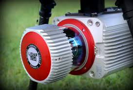
Harris Aerial, an innovative drone manufacturer near Orlando, FL, builds and sells heavylift hybrid multicopters. These copters use a small generator running on 95 (or higher) octane fuel to power the UAV for up to 5 hours. The Carrier H6 can carry an A-series HD LiDAR system of 3kg for 2.5 hours and a V-series of 5kg up to 1.5 hours. The benefit of this system is the multicopter meets and exceeds all the benefits the user expects.
For the LiDAR operator this translates into most projects requiring only one or two flights at most. On projects that are relatively flat with a clear LOS to the horizon in all directions, these systems can cover everything legally possible in a single flight.
Fortunately, as an integrated package with any LiDARUSA scanning system, the price is still well within reach of most mapping companies.
Visit www.lidarusa.com for more information and sample data sets.
LiDARUSA is committed to promoting LiDAR mapping and imaging around the globe.
About LiDARUSA
LiDARUSA, also known as Fagerman Technologies, is a family owned business just outside of Huntsville, AL. LiDARUSA specializes in laser scanning, photogrammetry, instrumentation and all things geomatics. Years of experience working on best-in-class products have developed our sense of quality and leadership necessary to build only the best systems.
About Harris Aerial
Harris Aerial is a heavy-lift drone manufacturer located just outside of Orlando, FL. Harris Aerial specializes in battery and gas-electric UAV design, hardware manufacturing, and sensory and custom payload integration for applications spanning various industrial sectors.
