Asian Surveying & Mapping
Breaking News
Launch of Australia’s 1st orbital rocket, Gilmour Space’s Eris-1, delayed again
Update for 6:15 p.m. ET on July 1: Gilmour Space...
SAASST, UAE Space Agency strengthen scientific partnership
SHARJAH- Prof. Hamid M.K. Al Naimiy, Director of the...
Shubhanshu Shukla to speak to students and ISRO scientists this Friday
Indian astronaut Shubhanshu Shukla will interact with school students...
ISRO hands over 10 advanced technologies to Indian firms in major push for space commercialisation
The Indian Space Research Organisation (ISRO) has transferred ten...
DIGIPIN Launched: India Embraces Geospatial Precision in Digital Addressing
IIT Hyderabad (IITH), in partnership with the Department of...
HAL to build, market Isro’s SSLV in landmark deal
New Delhi, Jun 20: In a historic move for...
Taiwan developing space capabilities for all-weather imaging
TAIPEI (TVBS News) — Taiwan is advancing its space...
Honda hails successful test of reusable rocket as it looks to get into the space business
Tokyo — Japan's second-biggest carmaker, Honda, has successfully tested...
China’s space program provides larger platform for broader international cooperation
BEIJING -- Experts from China's manned space program said...
India To Launch $1.5 Billion Joint Earth Mission With NASA In July
National Aeronautics and Space Administration (NASA) and the Indian...

August 1st, 2017
Free Point of Interest Data by Type for Use with Maptitude Mapping Software

NEWTON, MA (USA) – Point files with the locations of U.S. points of interest are now downloadable for free for Maptitude 2017.

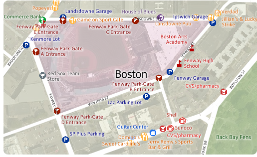
The download includes point layers for 86 categories of location in the USA, including shopping malls, banks, restaurants, clothing stores, auto dealerships, grocery stores, pharmacies, and hospitals. These new layers are perfect for site locationcompetitive analysisrouting, and real estate reports. The layers have attractive icons and can be added to any Maptitude 2017 map (more…).

Maptitude includes a vast amount of business critical data at no additional cost, such as demographics, boundaries, streets, and the most accurate ZIP Code/postal boundaries available. If you have any questions about Maptitude or data availability contact Caliper.

About Caliper

Caliper Corporation develops state-of-the-art Geographic Information Systems (GIS) software. With a focus on usability, Maptitude is designed to be a cost-effective, professional healthcare mapping software product. Maptitude enables organizations to leverage their location-based data to improve decision making and planning, while minimizing expenditure through competitively priced solutions.

Caliper is a privately held corporation and is a leading developer of mapping, redistricting, transportation, and GIS software.