Asian Surveying & Mapping
Breaking News
Tata Deploys Its Geospatial Satellite In Space on Space X’s Falcon 9 Rocket
THIRUVANANTHAPURAM: Tata Company launched India's first private commercial satellite...
Taiwan’s Formosat-8 Satellite Set for Launch by 2025
The Taiwan Space Agency has announced progress on the...
Iranian Scientists to Build Satellite Constellation for 2 Simultaneous Missions
The scientists at the knowledge-based company had previously succeeded...
China provides geospatial intel and other military support to Russia, US says
The US has warned its European allies that China...
Japanese lunar lander company ispace raises $53.5 million in stock sale
WASHINGTON — Japanese lunar lander developer has raised $53.5...
Esri and Prince Sultan University Advance GIS Education Through Strategic Partnership
Memorandum of Understanding with Institution Enhances GIS Curriculum and...
China launches 3rd group of Yunhai-2 satellites for observation
China launches third set of Yunhai-2 satellites for monitoring...
South Korea to launch second spy satellite in early April
South Korea plans to launch its second military satellite...
China launched the second batch of Yunhai-2 satellites
China has launched a new batch of Yunhai-2 weather...
UB Singapore students win geospatial competition with food waste research
UB students in Singapore mapping food waste across the...

korea

Friday, February 24th, 2012

Korea Ready to Fund $40 Million for Baku City Cadastre

Today in Baku Garib Mammadov, chairman of the State Land & Cartography Committee of Azerbaijan, has claimed that at present within the project supported by the Korean government it is being developed the urban cadastre of Khazar...

Saturday, December 10th, 2011

Four Korean Satellites Expected to Be Launched in 2012

The Korea Aerospace Research Institute said that a multi-purpose satellite named Arirang-5 will take off from the Yasny rocket launch site in Russia next year. One of four Korean satellites planned for 2012, the Arirang-5 is the nation's...

Thursday, October 6th, 2011

Hanyang Univ College of Engineering Nurturing Korea’s Engineers of Tomorrow

"Over 52,000 graduates have passed through the gates of Hanyang University College of Engineering (HUCE), and all have been part of the modernization of Korea that happened in the last few decades, from key personnel of national...

Monday, August 8th, 2011

Korea Protests US Agency’s Support for ‘Sea of Japan’

Korea has lodged an informal protest against a U.S. government-funded agency’s suggestion to use Japan’s name for the body of water between the two Asian nations in the world’s most-cited guideline for maps, diplomatic sources said Monday. The...

Thursday, June 9th, 2011

IWA World Water Congress & Exhibition 2012 Busan, Korea

Welcome to the International Water Association (IWA)’s first electronic newsletter for the next IWA World Water Congress & Exhibition which will be held in Busan, South Korea from 16 to 21 September 2012. As planning proceeds and...

Monday, February 28th, 2011

ETRI Korea Develops GPS/Galileo Receiver

The Electronics and Telecommunications Research Institute (ETRI) of Korea announced that it had completed the technology development of a GPS (US Global Positioning System) and Galileo (Europe's Global Navigation Satellite System, GNSS) receiver, which was able to receive and process positioning signals both...

Thursday, February 10th, 2011

Korea’s Cartographic Legacy

About two months ago, renowned Korean scholar Choi Suh-myun received an unexpected package from Atsushi Hirata, director of the Ryukoku University Library in Japan. Choi was taken aback by its content: a masterful digitally enhanced recreation of a...

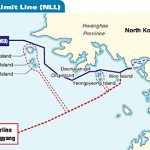
Thursday, November 25th, 2010

Value of a Map: North Korea – South Korea

This past week saw North Korea launch live ammunition into South Korea. The event has raised tensions in the region. While the original border between these two countries was mapped when the Armistice was signed in 1953,...