Asian Surveying & Mapping
Breaking News
Australian Space Agency funds development of aerospace-grade GNSS receiver
The Australian Space Agency has funded the development of...
Continuity risks for Australian EO data access
A new report details the widespread use of Earth...
China launches new remote sensing satellite
JIUQUAN, April 15 (Xinhua) -- China on Monday launched...
7.4-Magnitude Earthquake Strikes Taiwan
A major, 7.4-magnitude earthquake struck the eastern coast of...
Tata Deploys Its Geospatial Satellite In Space on Space X’s Falcon 9 Rocket
THIRUVANANTHAPURAM: Tata Company launched India's first private commercial satellite...
Taiwan’s Formosat-8 Satellite Set for Launch by 2025
The Taiwan Space Agency has announced progress on the...
Iranian Scientists to Build Satellite Constellation for 2 Simultaneous Missions
The scientists at the knowledge-based company had previously succeeded...
China provides geospatial intel and other military support to Russia, US says
The US has warned its European allies that China...
Japanese lunar lander company ispace raises $53.5 million in stock sale
WASHINGTON — Japanese lunar lander developer has raised $53.5...
Esri and Prince Sultan University Advance GIS Education Through Strategic Partnership
Memorandum of Understanding with Institution Enhances GIS Curriculum and...

fugro

Monday, June 5th, 2017

Fugro Partners with Skyline to Deliver Unique Oblique Imagery and 3D Modelling Environment

Fugro is enhancing its mapping services with the introduction of an integrated software package that creates realistic, yet spatially accurate, high-resolution 3D building models using oblique imagery. The product will benefit emergency responders during critical infrastructure planning,...

Monday, February 20th, 2017

Fugro Announces Partnership with Shell Ocean Discovery XPRIZE

Fugro today announced a partnership with the Shell Ocean Discovery XPRIZE to support first round testing of the global, three-year competition, which incentivises development of rapid, unmanned and high resolution ocean mapping technologies. Fugro’s role is to...

Wednesday, December 7th, 2016

Fugro’s Airborne Technology Deployed In Response To New Zealand Earthquake

Fugro’s LADS technology is being deployed in New Zealand to assist in relief efforts following the damaging 7.9 magnitude earthquake near Christchurch on 14th November 2016. At the request of the New Zealand Government, the Royal Australian...

Friday, November 18th, 2016

Fugro Signs Multi-Year Survey Contract With U.S. Government

Fugro was recently awarded a five-year survey contract by the United States Army Corps of Engineers (USACE). Task orders under this indefinite delivery, indefinite quantity (IDIQ) type contract will support the Architect and Engineering Survey and Mapping...

Thursday, January 19th, 2012

Fugro Reflects on Past Year, and Points to Areas of Success

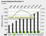
Fugro, a global geospatial and geoscience services company trading on Euronext Amsterdam, took the opportunity at the start of the year to reflect on the turbulence of 2011 as well as their contiued growth. The company achieved...

Thursday, September 1st, 2011

MEO Buys Into Fugro 3D Seismic Survey Offshore Western Australia

MEO Australia Ltd. has purchased 323 sq km (125 sq mi) of Fugro Multi Client Services Pty Ltd. seismic survey with processing to come from offshore Western Australia in permit WA-361-P. MEO says this fulfills the work commitment for year...