Tuesday, February 14th, 2017
A new JavaScript library, called GWIS (Graphing Water Information System), can create time-series plots of information measured at U.S. Geological Survey hydrologic data collection sites across the United States. Developed by the USGS Texas Water Science Center, the user-friendly interface integrates...
Tuesday, January 17th, 2017
An annual award for outstanding achievement in remote sensing A longtime innovator in space-based Earth observation at Boston University and a team that has paved the way for the next generation of satellite precipitation observations have both...
Tuesday, January 10th, 2017
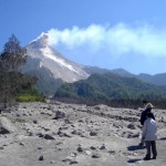
Indonesia has the world’s greatest at-risk population for volcano hazards and is the most volcanically active nation on Earth. To help mitigate potential disasters to its country and people, the Indonesian Center for Volcanology and Geologic Hazard...
Tuesday, January 3rd, 2017
Reston, VA – MAPPS (www.mapps.org), the national association of private sector geospatial firms, today announced the release of model legislation for state legislaturesto help coordinate state level partnerships for the collection of enhanced elevation data in support...
Tuesday, December 27th, 2016
The entire population of southwestern Idaho’s Gem County depends on aquifers for its drinking water. The water in those aquifers is of generally good quality according to a U.S. Geological Survey report released today. The study was...
Tuesday, November 22nd, 2016
The Open Geospatial Consortium (OGC®) is inviting members and the public to attend the OGC Testbed 12 demonstration and exposition of the technology developed during its latest Interoperability Program initiative on 29 November 2016 at the USGS...
Tuesday, November 15th, 2016
COLORADO SPRINGS, Colo.- The Sanborn Map Company, Inc. (Sanborn) has won a Geospatial Products and Services Contracts (GPSC) award from the U.S. Geological Survey (USGS) that allows the agency to negotiate task orders with Sanborn during the next...
Thursday, June 18th, 2015
June 18, 2015 — On June 18, 2015 in Canberra, Australia, the U.S. Geological Survey and Geoscience Australia signed a comprehensive new partnership to maximize land remote sensing operations and data that can help to address issues...
Friday, August 5th, 2011
With decades of experience in developing country-scale geographic information system (GIS) databases and in performing major geologic mapping and resource assessment programs within the Middle East, Eurasia, Asia and South America, the USGS is working to develop...
Tuesday, May 4th, 2010
Vexcel Imaging GmbH, a Microsoft company, announced that it received notice from the United States Geological Survey (USGS) that the UltraCamXp and UltraCamXp Wide Angle (WA) successfully completed the USGS Sensor Type Certification Process. USGS certifies that...
