Tuesday, August 30th, 2011
In a major breakthrough to enhance the Sultanate’s preparedness against a possible tsunami, a scientist at the Sultan Qaboos University (SQU) has suggested a hazard map for the country to be well-equipped. Learning from the best practices...
Tuesday, August 9th, 2011
The calving of icebergs (where a huge chunk of ice breaks off from a glacier or ice shelf) from the Sulzberger Ice Shelf in Antarctica was linked to the tsunami, which originated with the magnitude 9.0 earthquake off the...
Wednesday, August 3rd, 2011
Australian scientists are putting the finishing touches on a highly advanced tsunami warning system in a remote desert region north of Perth. Researchers say the array of sensors is the first in the world able to make...
Thursday, July 28th, 2011
The 2004 Asian Tsunami caused dramatic damage, but there are other threats. Remote sensing technologies are evolving quickly and provide tools for monitoring such tropical forests so the team set out to compare three methods. Image differencing is...
Friday, June 24th, 2011
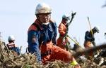
As Japan works to rebound from the devastating earthquake and tsunami, leaders, planners and academics are working to put back the pieces and lay the groundwork for new development. Leaders are conscious of the world's attention, and...
Monday, May 2nd, 2011
He went on to say: "Some argue that the tsunami's ferocity shows that existing protections were inadequate. The mayor of Rikuzentakata — a small city in Iwate Prefecture that I visited a few days after the disaster,...
Wednesday, April 20th, 2011
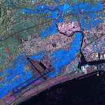
Pooling the best and most up-to-date images and model results, a new GEO Geohazard Supersite has been established to advance scientific understanding of the Japanese earthquake and tsunami and support recovery operations. Meanwhile, theInternational Charter on Space and Major...
Tuesday, April 19th, 2011
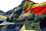
The ability to analyze, model and simulate natural disaster events and their consequences is unique to the geospatial and geomatics sector. No other tools provide data management, analysis and the associated visual output, useful for decision-making purposes...
Thursday, March 24th, 2011
The German Remote Sensing Data Center (Deutsches Fernerkundungsdatenzentrum; DFD) and the German Space Operations Center (GSOC), both of which are part of the German Aerospace Center (Deutsches Zentrum für Luft- und Raumfahrt; DLR), are continuing to provide...
