Asian Surveying & Mapping
Breaking News
Australian Space Agency funds development of aerospace-grade GNSS receiver
The Australian Space Agency has funded the development of...
Continuity risks for Australian EO data access
A new report details the widespread use of Earth...
China launches new remote sensing satellite
JIUQUAN, April 15 (Xinhua) -- China on Monday launched...
7.4-Magnitude Earthquake Strikes Taiwan
A major, 7.4-magnitude earthquake struck the eastern coast of...
Tata Deploys Its Geospatial Satellite In Space on Space X’s Falcon 9 Rocket
THIRUVANANTHAPURAM: Tata Company launched India's first private commercial satellite...
Taiwan’s Formosat-8 Satellite Set for Launch by 2025
The Taiwan Space Agency has announced progress on the...
Iranian Scientists to Build Satellite Constellation for 2 Simultaneous Missions
The scientists at the knowledge-based company had previously succeeded...
China provides geospatial intel and other military support to Russia, US says
The US has warned its European allies that China...
Japanese lunar lander company ispace raises $53.5 million in stock sale
WASHINGTON — Japanese lunar lander developer has raised $53.5...
Esri and Prince Sultan University Advance GIS Education Through Strategic Partnership
Memorandum of Understanding with Institution Enhances GIS Curriculum and...

Taiwan

image

Tuesday, August 29th, 2017

SpaceX Launches Taiwan’s Earth-Observation Satellite

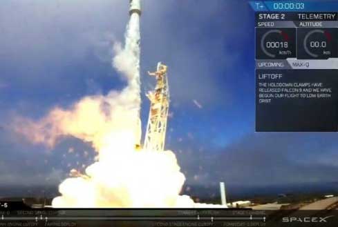
SpaceX successfully launched FORMOSAT-5, the first fully Taiwan-made Earth observation satellite, from Vandenberg Air Force Base in California on Aug. 24, 2017, nearly four years after its original intended late-2013 launch. The 475-kilogram satellite was sent into...

Saturday, March 17th, 2012

Performance Evaluation of Taiwan Local Governments on “2011 Cadastral Map Resurvey Project”

Local governments have completed “2011 Cadastral Map Resurvey Project”  To clarify cadastral disputes on land boundaries, NLSC looks forward to continuing cooperation with local governments to execute cadastral map resurvey project.  Read More

Thursday, January 26th, 2012

GIS Research Center Taiwan – 1st Cloud-based Municipal Works Map Platform

FCU’s Geographic Information Systems (GIS) Research Center has successfully applied Google Earth Enterprise cloud technology to the completion of Taiwan’s first municipal works cloud-based map platform. This project was commissioned by the Taichung City Government. With the...

Friday, January 20th, 2012

Taiwan 2012 Surveying and Mapping Technical Speech

For promoting the surveying and mapping technique, Dr. Lu Erh-Sang, the chairman of the Chinese Society of Cadastral Survey, was invited to make speech at the National Land Surveying and Mapping Center (NLSC) on January 12, 2012....

Tuesday, December 13th, 2011

SuperGeo Announces SuperGIS Online Website

SuperGeo announces that SuperGIS Online Website is officially launched, making the GIS data and services accessible through the Internet.

Friday, November 18th, 2011

TWD97 Coordinates Update Forum Ended Successfully

Ministry of the Interior held the forum on the TWD97 coordinates update at the NLSC, Taichung City on Oct. 28, 2011. The present situation of the TWD97 coordinate system, analyses to the coordinate results of the existing...

Friday, November 18th, 2011

Taiwan – Discussion over Uses of e-GPS Data on Judicial Cases

In order to enhance the function for full-time monitoring the outdoors whereabouts and movements of convicts, the 3rd generation monitoring equipment is planned to integrate the GPS technology. On Oct 26, 2011, judicial officers, the 27 members...

Thursday, October 13th, 2011

Taiwan President Unveils New Massive Infrastructure Plan

President Ma Ying-jeou unveiled Wednesday a large-scale infrastructure plan targeting roads, railways, water treatment systems and broadband Internet connection to increase Taiwan's competitiveness. The plan would also make the country a more attractive and convenient place for...

Thursday, October 6th, 2011

Successfully Completed the e-GPS User Forum in 2011

The National Land Surveying and Mapping Center (NLSC) held the e-GPS user forum at the International Conference Hall of the Chemistry and Material, National Chung Hsing University, on Sep. 22 2011. Professionals at the various aspects of...

Thursday, September 1st, 2011

High-Speed Rail + High-Speed WiMax in Taiwan

This week the Bureau of High-Speed Rail in Taiwan (HSR) decided to innovate railway transportation through providing 4G wireless internet. This is a clear sign that being connected, even while moving at high-speed, knows no bounds and...

Page 1 of 2 1 2