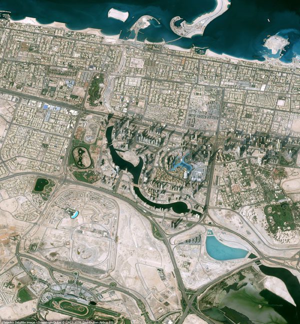
Monday, November 13th, 2017
The CNES (Space Agency of France) Pléiades satellite acquired this image of Downtown Dubai, including some of Dubai's most well-known landmarks: the Burj Khalifa, Dubai Mall and Dubai Fountain. Due to the presence of these famous sites,...
Monday, October 2nd, 2017
Although its space industry employs about 11,500 people, Australia is one of the few major developed countries to not have a space agency. But that’s about to change after a domestic industry review called for a dedicated...
Monday, August 14th, 2017
A workshop on "Popularisation of Remote Sensing based maps and Geospatial Information" on National Remote Sensing Day to commemorate the birth anniversary of Dr. Vikram Sarabhai (the father of Indian Space Programme) was jointly organised by Indian...
Wednesday, August 2nd, 2017
JERSEY CITY, N.J — Verisk Analytics (Nasdaq:VRSK), a leading data analytics provider, today announced a range of new capabilities in its Geomni business unit. The Geomni Remote Sensing Fleet Verisk recently acquired a number of leading U.S.-based...
Tuesday, August 1st, 2017
About $180 million will be required to create a Belarusian-Russian satellite for the remote sensing of Earth, BelTA learned from Piotr Vityaz, Head of the Office of the National Academy of Sciences of Belarus. Read More at...
Monday, July 3rd, 2017
Study aided by remote sensing and GIS reveals erosion of as many as 18 forested island. Read More at The Hindu
Tuesday, May 30th, 2017
Russia needs to build up the orbital grouping with at least 15 spacecrafts operating in the orbit by 2020 to provide remote sensing of Russia and the whole world, Russian President Vladimir Putin said Monday. Read More...
Monday, May 1st, 2017
Thousands of hectares of forest land in Munnar, one of the world’s greatest biodiversity hotspots, have disappeared, remote sensing data shows. Read More at Mint
Thursday, April 27th, 2017
Space Flight Laboratory (SFL), a provider of complete microspace missions, will present papers on the successful GHGSat-D greenhouse gas monitoring and CanX-7 aircraft tracking nanosatellite missions next week in Berlin, Germany, at the 11th IAA Symposium on...
Monday, April 3rd, 2017
The Eurasian Economic Union (EAEU) plans to create a joint remote earth sensing system by integrating the space- and ground-based capabilities of its member states, to include Russia, Kyrgyzstan, Armenia, Belarus, and Kazakhstan, by 2019. Read More...
