Asian Surveying & Mapping
Breaking News
Australian Space Agency funds development of aerospace-grade GNSS receiver
The Australian Space Agency has funded the development of...
Continuity risks for Australian EO data access
A new report details the widespread use of Earth...
China launches new remote sensing satellite
JIUQUAN, April 15 (Xinhua) -- China on Monday launched...
7.4-Magnitude Earthquake Strikes Taiwan
A major, 7.4-magnitude earthquake struck the eastern coast of...
Tata Deploys Its Geospatial Satellite In Space on Space X’s Falcon 9 Rocket
THIRUVANANTHAPURAM: Tata Company launched India's first private commercial satellite...
Taiwan’s Formosat-8 Satellite Set for Launch by 2025
The Taiwan Space Agency has announced progress on the...
Iranian Scientists to Build Satellite Constellation for 2 Simultaneous Missions
The scientists at the knowledge-based company had previously succeeded...
China provides geospatial intel and other military support to Russia, US says
The US has warned its European allies that China...
Japanese lunar lander company ispace raises $53.5 million in stock sale
WASHINGTON — Japanese lunar lander developer has raised $53.5...
Esri and Prince Sultan University Advance GIS Education Through Strategic Partnership
Memorandum of Understanding with Institution Enhances GIS Curriculum and...

high-resolution

Wednesday, March 21st, 2012

Baidu Boosts China Mapping Service With More Images

Baidu, China's dominant online search service, said on Monday that it has signed a multiyear subscription deal with commercial imagery company DigitalGlobe. Baidu aims to improve its online mapping service to better compete with its chief rival, Google. By...

Sunday, March 4th, 2012

Airborne Search and Rescue Detection & Geotagging Development

Software and hardware engineering efforts at ITRES have moved into the next phase towards integrating our In-Flight Processing System (IPS) development with new highresolution pushframe thermal TABI-1800 imager. “This is a big milestone for us. It moves...

Tuesday, February 14th, 2012

Blom ASA and Unicom – Contract Win in Saudi Arabia

Blom CGR, the Italian subsidiary of Blom ASA, has partnered with the Saudi Arabian firm Unicom to secure a contract with the Development Commission of Medina (DCOM). The contract involves providing professional services for the production of...

Tuesday, January 17th, 2012

GeoEye Selects Cleversafe for Satellite Imagery Active Archive

GeoEye has selected Cleversafe, Inc., to meet its requirements for a highly reliable and secure active archive  to support their business mission and to maintain their image archive.

Tuesday, January 10th, 2012

China Opens 2012 with ZiYuan-3 Launch via Long March 4B

China launched a new high-resolution remote sensing satellite on Monday at 03:17 UTC using the Long March 4B (Chang Zheng-4B -Y26) launch vehicle from the Taiyuan Satellite Launch Center. According to the official Xinhua News Agency, the...

Monday, January 9th, 2012

Digital Revenue Record to Ease Preparing Land Database

The entire revenue record of Haryana would be digitised and updated using high resolution satellite imageries for the seamless preparation of a database of land records. The updated maps would be geo-referenced using the benchmark Ground Control...

Wednesday, September 21st, 2011

Manila’s Natural Disaster Risk Areas in 3D Maps

Areas in Metro Manila at high risk during natural disasters may now be known through an accurate hazard map, a product of Australia’s high-resolution three-dimensional mapping technology, which had been turned over to the Philippine government recently. Australian...

Thursday, August 11th, 2011

New Zealand Embarks on Four-Year, $4 Million Mapping Programme

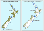
The government of New Zealand has announced a research programme today to use satellite imagery and geospatial mapping to map forests, pastures, rivers and cities across the country. The four-year Land Cover Research Programme was launched with...

Tuesday, July 5th, 2011

Port Moresby From Space: New 50cm Sat Imagery Available

The GeoEye-1 satellite has recently imaged the Port Moresby region over the last few months and obtained some remarkable, cloud free datasets.   “Given the economic activity in this region and elsewhere in New Guinea, the interest in...