Asian Surveying & Mapping
Breaking News
Australian Space Agency funds development of aerospace-grade GNSS receiver
The Australian Space Agency has funded the development of...
Continuity risks for Australian EO data access
A new report details the widespread use of Earth...
China launches new remote sensing satellite
JIUQUAN, April 15 (Xinhua) -- China on Monday launched...
7.4-Magnitude Earthquake Strikes Taiwan
A major, 7.4-magnitude earthquake struck the eastern coast of...
Tata Deploys Its Geospatial Satellite In Space on Space X’s Falcon 9 Rocket
THIRUVANANTHAPURAM: Tata Company launched India's first private commercial satellite...
Taiwan’s Formosat-8 Satellite Set for Launch by 2025
The Taiwan Space Agency has announced progress on the...
Iranian Scientists to Build Satellite Constellation for 2 Simultaneous Missions
The scientists at the knowledge-based company had previously succeeded...
China provides geospatial intel and other military support to Russia, US says
The US has warned its European allies that China...
Japanese lunar lander company ispace raises $53.5 million in stock sale
WASHINGTON — Japanese lunar lander developer has raised $53.5...
Esri and Prince Sultan University Advance GIS Education Through Strategic Partnership
Memorandum of Understanding with Institution Enhances GIS Curriculum and...

Geospatial1

Tuesday, January 16th, 2018

India’s PSLV Launches Cartosat-2

On Jan. 12, 2018, India’s Polar Satellite Launch Vehicle (PSLV-C40), in its 42nd flight, successfully launched from the Satish Dhawan Space Centre the 710-kilogram Cartosat-2 satellite for Earth observation as well as 30 co-passenger satellites. The co-passenger...

Tuesday, December 5th, 2017

JAXA and VNSC Sign Cooperation Agreement

On Nov. 17, 2017, the Vietnam National Space Center (VNSC) and the Japan Aerospace Exploration Agency (JAXA) agreed to cooperate in the field of Public Affairs. JAXA will provide scale models to be exhibited at the Vietnam...

Monday, November 20th, 2017

New Map of Worldwide Croplands Supports Food and Water Security

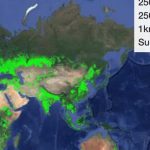
India has the highest net cropland area while South Asia and Europe are considered agricultural capitals of the world   A new map was released detailing croplands worldwide in the highest resolution yet, helping to ensure global...

Monday, November 13th, 2017

Satellite Images Downtown Dubai Landmarks

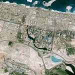
The CNES (Space Agency of France) Pléiades satellite acquired this image of Downtown Dubai, including some of Dubai's most well-known landmarks: the Burj Khalifa, Dubai Mall and Dubai Fountain. Due to the presence of these famous sites,...

Monday, November 6th, 2017

India Maps 185 Districts Through Remote Sensing for Horticulture

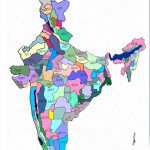
India’s Union Ministry of Agriculture mapped 185 districts under a project using remote-sensing technology to identify areas best suited for seven different fruits and vegetables across the country. The first report, for eight states in the North...

Tuesday, July 25th, 2017

New Research Uses Satellites to Predict End of Volcanic Eruptions

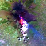
Researchers from the University of Hawaiʻi at Mānoa School of Ocean and Earth Science and Technology (SOEST) recently discovered that infrared satellite data could be used to predict when lava flow-forming eruptions will end. Using NASA satellite...