Tuesday, May 2nd, 2017
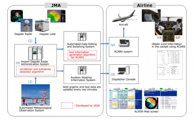
In April 2017, the Airport Low-level Wind Information (ALWIN) system, jointly developed by the Japan Meteorological Agency (JMA) and the Japan Aerospace Exploration Agency (JAXA), started operations at Tokyo International Airport (Haneda) and Narita International Airport. ALWIN...

Tuesday, April 18th, 2017
NASA recently released new global nighttime images of the Earth, including a detailed view of India and its surroundings that show how patterns of human settlement changed across the country between 2012 and 2016. Satellite images of...

Tuesday, April 11th, 2017
Satellite radar scans of the 7.8-magnitude Nov. 14, 2016, earthquake in New Zealand are changing the way scientists think about earthquake hazards in regions where Earth’s tectonic plates meet. The quake struck near the town of Kaikoura...

Monday, April 3rd, 2017
Earth-i is following up its successful tender award from the Government of Queensland by supporting the International Symposium on Digital Earth & Locate 17 Conference being held in Sydney, Australia, from April 3-6, 2017. The Queensland Department...
Tuesday, March 21st, 2017
Japan launched a new spy satellite into orbit on March 17, 2017, to help keep an eye on its nuclear-armed neighbor, North Korea. The Information Gathering Satellite (IGS) Radar 5 lifted off atop a Japanese H-IIA rocket...

Tuesday, March 14th, 2017
If a two-year trial of Satellite Based Augmentation Systems (SBAS) being undertaken with the backing of the Australian and New Zealand governments proves successful, position fixing could become more precise than the several-meters accuracy provided by Global...

Tuesday, March 7th, 2017
An 800-year-old puzzle about the burial place of Mongolian ruler Genghis Khan sparked a very 21st century business. Albert Lin was on an expedition to locate the lost tomb of the Mongol Empire founder, when satellite imagery...
Tuesday, February 28th, 2017
The Japan Aerospace Exploration Agency (JAXA) announced that its H-II Transfer Vehicle KOUNOTORI6 (HTV6), after completion of deorbit maneuver, reentered Earth according to schedule on Feb. 5, 2017. KOUNOTORI6 berthed to the International Space Station (ISS) on...
Tuesday, February 21st, 2017
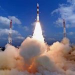
On Feb. 15, 2017, India’s space agency (ISRO) successfully launched a record 104 satellites on a single rocket; this is the highest number of satellites ever launched in a single mission. The Polar Satellite Launch Vehicle PSLV-C37...

Monday, February 6th, 2017
As of January 2017, Australia’s coordinates officially moved 1.8 meters northeast, following the launch of the Geocentric Datum of Australia 2020 (GDA2020). The first update to Australia’s coordinate system in two decades, GDA2020 is a step toward...
