Asian Surveying & Mapping
Breaking News
Australian Space Agency funds development of aerospace-grade GNSS receiver
The Australian Space Agency has funded the development of...
Continuity risks for Australian EO data access
A new report details the widespread use of Earth...
China launches new remote sensing satellite
JIUQUAN, April 15 (Xinhua) -- China on Monday launched...
7.4-Magnitude Earthquake Strikes Taiwan
A major, 7.4-magnitude earthquake struck the eastern coast of...
Tata Deploys Its Geospatial Satellite In Space on Space X’s Falcon 9 Rocket
THIRUVANANTHAPURAM: Tata Company launched India's first private commercial satellite...
Taiwan’s Formosat-8 Satellite Set for Launch by 2025
The Taiwan Space Agency has announced progress on the...
Iranian Scientists to Build Satellite Constellation for 2 Simultaneous Missions
The scientists at the knowledge-based company had previously succeeded...
China provides geospatial intel and other military support to Russia, US says
The US has warned its European allies that China...
Japanese lunar lander company ispace raises $53.5 million in stock sale
WASHINGTON — Japanese lunar lander developer has raised $53.5...
Esri and Prince Sultan University Advance GIS Education Through Strategic Partnership
Memorandum of Understanding with Institution Enhances GIS Curriculum and...

geo

image

Tuesday, October 17th, 2017

Invisible Solar Nanoflares Confirmed by Ultra-High-Sensitivity Observations

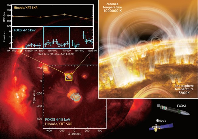
An international research team led by Dr. Shin-nosuke Ishikawa, project research fellow of the Japan Aerospace Exploration Agency (JAXA), succeeded in detecting the subtle signs of nanoflares in a region of the solar corona where no discernible...

Friday, March 17th, 2017

Launch of INTERGEO 2017: Topics that Get the Geo-IT Sector Noticed

Berlin | 3, 2, 1 and lift-off. The 2017 INTERGEO season is underway, with a programme fully reflecting its long-standing key focus – “Knowledge and action for planet Earth”. Once again in 2017, the leading international trade...

Thursday, March 31st, 2016

GSDI 15 World Conference Keynote Speakers Announced!

The Global Spatial Data Infrastructure (GSDI) Association is pleased to announce that Mark Reichardt, President of the Open Geospatial Consortium (OGC), and Barbara Ryan, Secretariat Director of the Intergovernmental Group on Earth Observations (GEO), will deliver two...

Wednesday, April 20th, 2011

GEO Supersite Monitors, Models the Sendai Disaster

Pooling the best and most up-to-date images and model results, a new GEO Geohazard Supersite has been established to advance scientific understanding of the Japanese earthquake and tsunami and support recovery operations. Meanwhile, theInternational Charter on Space and Major...