Saturday, March 12th, 2011
The magnitude 8.8 earthquake that jolted northeast Japan was caused by a tectonic upheaval that created offshore faults stretching for hundreds of kilometers from Iwate Prefecture to Ibaraki, seismologists said Saturday. Satoko Oki of the University of Tokyo's...
Saturday, March 12th, 2011
In response to the devastating Japan earthquake and tsunami, Esri is providing assistance to a myriad of organizations involved in the disaster response. The company is working closely with both domestic and international...
Friday, March 11th, 2011
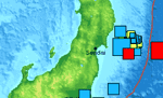
An 8.9 magnitude earth earthquake has struck off the coast of northern Japan. The earthquake has generated a 10 m high tsunami that is reportedly extending a kilometer inland in some locations. Japan sits atop one of...
Sunday, March 6th, 2011
Earthquake vulnerability tests have been conducted in some 19,000 buildings in Dhaka, Chittagong and Sylhet, the disaster management minister tells parliament. "All the buildings will be examined step by step. Moreover, initiatives have been taken to develop a...
Thursday, March 3rd, 2011
In the aftermath of the devastating earthquake in Christchurch last week, there is such a prevalent feeling amongst those not directly involved in or affected by events, to offer help in some way. For those of us...
Wednesday, March 2nd, 2011
Until March 5, all proceeds from Apple and Mac applications made in New Zealand will go to the Red Cross to help victims of last Tuesday’s earthquake in Christchurch. Mapping, exercise and gaming applications are just some of...
Tuesday, February 22nd, 2011
At 12:51 p.m. on February 22, 2011 a magnitude 6.3 earthquake hit the South Island of New Zealand near the city of Christchurch. The Esri distributor in New Zealand, Eagle Technology Group in collaboration with Environment Canterbury has...
Tuesday, December 14th, 2010
Australia has a low seismicity (or rate of occurrence of earthquakes) when compared to countries located along tectonic plate boundaries such as New Zealand or Indonesia. Seismic risk, however, is the combination of hazard, community exposure and...
Thursday, June 24th, 2010
New airborne remote sensing techniques and tools are helping scientists gain a better understanding of earthquakes. Airborne sensors provide the advantage of being able to cover a great deal of ground,...
