Asian Surveying & Mapping
Breaking News
Australian Space Agency funds development of aerospace-grade GNSS receiver
The Australian Space Agency has funded the development of...
Continuity risks for Australian EO data access
A new report details the widespread use of Earth...
China launches new remote sensing satellite
JIUQUAN, April 15 (Xinhua) -- China on Monday launched...
7.4-Magnitude Earthquake Strikes Taiwan
A major, 7.4-magnitude earthquake struck the eastern coast of...
Tata Deploys Its Geospatial Satellite In Space on Space X’s Falcon 9 Rocket
THIRUVANANTHAPURAM: Tata Company launched India's first private commercial satellite...
Taiwan’s Formosat-8 Satellite Set for Launch by 2025
The Taiwan Space Agency has announced progress on the...
Iranian Scientists to Build Satellite Constellation for 2 Simultaneous Missions
The scientists at the knowledge-based company had previously succeeded...
China provides geospatial intel and other military support to Russia, US says
The US has warned its European allies that China...
Japanese lunar lander company ispace raises $53.5 million in stock sale
WASHINGTON — Japanese lunar lander developer has raised $53.5...
Esri and Prince Sultan University Advance GIS Education Through Strategic Partnership
Memorandum of Understanding with Institution Enhances GIS Curriculum and...

China

Tuesday, July 7th, 2015

China Teams with Belgium on Earth Observation Mission

Beijing and Brussels approved last week a MOU (memorandum of understanding) for joint collaboration on satellite technology that could place both nations "at the forefront" to deliver vital information worldwide, as revealed by Belgian State Secretary of...

Sunday, July 5th, 2015

Chinese Air Force Checks Quake Area with Drones

China’s air force dispatched a drone to the site of an earthquake in the far-western region of Xinjiang on Friday to help in monitoring work, the first time it has used an unmanned aircraft for such a...

Sunday, September 21st, 2014

India Inks Agreement with China for Cooperative Remote Sensing Satellite Missions

The Indian Space Research Organisation (ISRO) has inked a collaborative agreement with the China National Space Administration to work on peaceful missions that include the remote sensing of natural disasters and natural resources. The agreement is the...

Wednesday, March 21st, 2012

Baidu Boosts China Mapping Service With More Images

Baidu, China's dominant online search service, said on Monday that it has signed a multiyear subscription deal with commercial imagery company DigitalGlobe. Baidu aims to improve its online mapping service to better compete with its chief rival, Google. By...

Monday, March 19th, 2012

Baidu.com Signs Multiyear Subscription for DigitalGlobe Imagery

DigitalGlobe  announced that China's most influential internet search portal, Baidu.com Inc. (NASDAQ: BIDU) ("Baidu"), has signed a subscription for DigitalGlobe high-resolution imagery covering 344 cities in China. This agreement will enable Baidu to provide its end-users with...

Monday, March 5th, 2012

Researchers Find Great Wall Section in Mongolia

Researchers say the structure, known as 'The Wall of Genghis Khan', wasn't built to keep in gazelles, as has been written in some history books. The journey was led by a British researcher and Great Wall enthusiast, William...

Tuesday, February 14th, 2012

Motion Pictured: How an Earthquake Warps a Landscape

A team of geologists from the U.S., Mexico and China are using light detection and ranging (LiDAR) laser altimetry to study how an earthquake can change a landscape. In particular, the geologists want to know more about...

Thursday, February 9th, 2012

China Unicom Asked to Apply for Online Maps License

China Unicom, the country's second largest mobile operator, has been asked to apply for a license for its Internet maps service, which is being operated without official approval, the mapping service regulator said. The company will be further...

Wednesday, February 1st, 2012

China: Surveying and Map Division Asserts 2012 Course

The Surveying, Geographic Information and Map Division in China asserted it's overall 2012 strategy this past week at a plenary meeting. Min Yi-jen acted as deputy director of the meeting, which focused upon new requirements and a...

Monday, January 23rd, 2012

China’s Tree Monitoring Sensors Map Disease

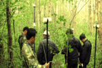
The ARBOTOM determines tree defects in 3D including stem quality using acoustic sensors. Pulses are transmitted through trees and return signals that provide an indication of the disease levels. Read More

Page 2 of 8 1 2 3 4 5 6 7 8