The Japan Aerospace Exploration Agency (JAXA) has undertaken the initial checkout and calibration of Shikisai, originally known as Global Change Observation Mission-Climate (GCOM-C), to start the satellite-derived data stream service in December 2018. Operation of the Shikisai satellite has been nominal since its launch on Dec. 23, 2017. On July 25, JAXA started the test stream service measures and has provided Japan Fisheries Information Service Center (JAFIC) with three types of nearly real-time data, including sea-surface temperature.
Observation images from Shikisai can yield higher-resolution images compared with other Earth-observation satellites that provide data used for fisheries. Additionally, the satellite’s multiple remote sensing, capable of simultaneous observation of ocean color and water temperature, will make the data applicable both to fisheries and marine research. Sea-surface temperature in the fishing grounds and other detailed information pertaining to the marine environment are expected to advance searching for productive fishing grounds. Data from Shikisai are also expected to enhance the monitoring of the coastal environment, making it possible to observe seaweed beds, tidal flats and algal blooms. It will contribute to the management of coastal marine resources and studies.
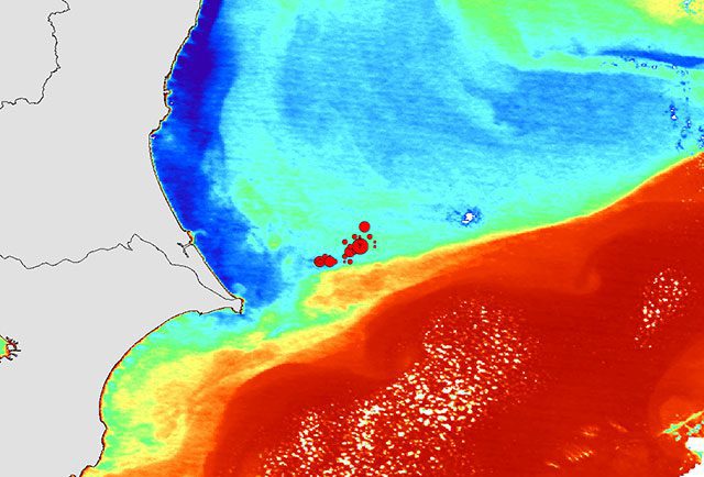
In this image, the coolest waters appear in blue, and the warmest temperatures appear in red. Red circles are fishing spots for Japanese pilchard (Sardinops melanostictus). A band of waters at high temperature (in red) along the Japan current lies on the south of the fishing ground. Warm water (orange to green) veers north, countercurrent, off from the Japan current. Cold water (blue) is distributed along the Kashima coast. This suggests fishing grounds are formed where warm waters move north.
JAFIC will cooperate with JAXA in calibration and verification of the data by supplying onsite surface temperature and other data. The Center will also use the test data distribution to implement the service that provides information with stakeholders such as those engaging in commercial fishing and research institutions. JAXA will use onsite measurements for comparison provided by JAFIC and other sources and continuously ensure the ongoing checkout and calibration of the satellite.


