Asian Surveying & Mapping
Breaking News
Australian Space Agency funds development of aerospace-grade GNSS receiver
The Australian Space Agency has funded the development of...
Continuity risks for Australian EO data access
A new report details the widespread use of Earth...
China launches new remote sensing satellite
JIUQUAN, April 15 (Xinhua) -- China on Monday launched...
7.4-Magnitude Earthquake Strikes Taiwan
A major, 7.4-magnitude earthquake struck the eastern coast of...
Tata Deploys Its Geospatial Satellite In Space on Space X’s Falcon 9 Rocket
THIRUVANANTHAPURAM: Tata Company launched India's first private commercial satellite...
Taiwan’s Formosat-8 Satellite Set for Launch by 2025
The Taiwan Space Agency has announced progress on the...
Iranian Scientists to Build Satellite Constellation for 2 Simultaneous Missions
The scientists at the knowledge-based company had previously succeeded...
China provides geospatial intel and other military support to Russia, US says
The US has warned its European allies that China...
Japanese lunar lander company ispace raises $53.5 million in stock sale
WASHINGTON — Japanese lunar lander developer has raised $53.5...
Esri and Prince Sultan University Advance GIS Education Through Strategic Partnership
Memorandum of Understanding with Institution Enhances GIS Curriculum and...
The Japan Aerospace Exploration Agency (JAXA) interviewed Kenichi Shishido, who is in charge of forestry and conservation projects at the Japan International Cooperation Agency (JICA), an independent administrative institution that coordinates official development assistance for the government of Japan. The agency uses data collected by JAXA’s Earth-observation satellites to plan its activities in the areas of forestry and conservation, water resources, disaster management and cartography.

“About 70 percent of Japan’s land is covered by forests, so our country is quite advanced in terms of experience, knowledge and technology in forest management,” said Shishido. “When we help developing countries establish forest-management practices, we bring all that experience.”

Uncontrolled or illegal logging has been accelerating. Every year around the world, about 3.3 million hectares of forest are lost. Forests absorb carbon dioxide, so protecting them is an important element of preventing global warming.

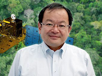
“We built a system that could immediately detect an illegal-logging site using data from JAXA’s Advanced Land Observing Satellite (ALOS),” noted Shishido. “The total area of the Brazilian Amazon is about 3.5 million square kilometers. It is such a wide region that to create an overview map, you need to synthesize about 300 scenes of satellite data. Once you have that map, by comparing images taken at different times, you can see where trees have been cut down. ALOS observed the Amazon every 46 days, and JAXA provided all the images to Brazil free of charge.”

Click here for the full interview.