

Tuesday, July 21st, 2020
China launched the Shiyan-6, its first modern scientific research vessel focusing on geophysical exploration and seismic acquisition and processing, in Guangzhou, South China's Guangdong Province. The launch is believed to be an important step in boosting the...
Tuesday, July 7th, 2020
A young volcanic island has been growing in the western Pacific Ocean since 2013. Since mid-June 2020, it has been going through a vigorous growth spurt. Images show some of the latest eruptive activity at Nishinoshima, a...

Tuesday, June 23rd, 2020
Nepalese people light candles as they celebrate after the Parliament approved a new map of the country, including areas disputed with India, in Kathmandu, Nepal. (Credit: Navesh Chitrakar/Reuters) The lower house of Nepal’s Parliament approved a...
Tuesday, June 9th, 2020
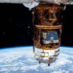
Japan’s resupply ship, the H-II Transfer Vehicle-9 (HTV-9), is pictured attached to the International Space Station’s Harmony module. Stowed inside the Japanese space freighter is the HTV-8 cargo pallet that was brought up to the station on...
Tuesday, May 26th, 2020
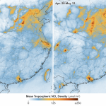
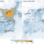
In early February 2020, scientists using NASA and European satellites detected a significant reduction in a key air pollutant over China after the country shut down transportation and much of its economy. Three months later, with most...
Tuesday, May 12th, 2020
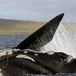
South Australian scientists are helping track southern right whales in search of summer foraging grounds, with a new report recording the first contemporary data on this seasonal migration. The study could provide valuable information in making guidelines...
Tuesday, April 28th, 2020
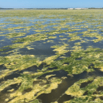
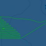
The satellite tracking is helping researchers map floating algae as it suffocates vital food plants in one of Australia’s most important bird habitats. Filamentous algae are decimating aquatic plants in the southern Coorong as it blocks seeding...
Tuesday, April 14th, 2020
An Australian aerial survey company is being accused by Kiwis of breaching lockdown rules, but it says it has been cleared to fly. Australia-based Nearmap has come under fire from Kiwi operators after allegedly completing survey flights...
Tuesday, March 31st, 2020
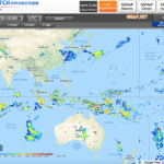
Global Satellite Mapping of Precipitation (GSMaP) has been developed by using multi-satellite products. The rainfall map is provided in real time and visualized every 30 minutes on the JAXA Realtime Rainfall Watch website. Please have a look...
Tuesday, March 24th, 2020
In countries and regions that have been under strict lockdowns to stop the spread of the coronavirus, an unintended consequence is visible from space. As businesses, industrial sites and factories closed, and cars and trucks stayed off...
