
Thursday, September 29th, 2011
The adoption of high precision GNSS in China is helping fuel a growth trajectory that is projected to double by 2016, according to ABI Research. While the market was impacted in 2009, there are multiple markets where...

Thursday, September 29th, 2011
Tunnelling has gone high-tech. Integrating survey data, monitoring information, data management and collaborative interaction, tunnelling is a shared effort and technologies are increasingly being integrated toward common web-based management systems. As tunnels proceed, machinery wear, alignment, shift...
Friday, September 23rd, 2011
Typhoon Roke came ashore in Japan this week causing considerable damage and several deaths. Beginning as a tropical depression 1370 km south of Japan in the Philippine Sea ten days previous, the storm ranged from a Category...
Friday, September 23rd, 2011
The Philippines is urging a meeting between the 10-member Association of South-East Asian Nations (ASEAN) and China to clearly map disputed areas in the South China Sea in order to reduce tensions. The meeting of ASEAN Maritime...

Friday, September 23rd, 2011
23 you have trouble viewing this, click here to view in a browser ASM Website Calendar Submit Editorial Satellites Follow Typhoon Roke Up CloseTyphoon Roke came ashore in Japan this week causing considerable damage and several...

Friday, September 23rd, 2011
23 you have trouble viewing this, click here to view in a browser ASM Website Calendar Submit Editorial Malaysia Commits to Expanding Satellite Earth Observation ProgramThe Malaysian government has made a five-year and RM200 million (US$66...

Friday, September 16th, 2011
The Internet of Things holds great promise with more objects and systems interconnected and available for query and data collection through Internet connectivity. IBM is leading the way with much of this development in a smarter city...

Friday, September 16th, 2011
If you have trouble viewing this, click here to view in a browser ASM Website Calendar Submit Editorial IBM's Chinese Lab Takes on Internet of ThingsThe Internet of Things holds great promise with more objects and...
Thursday, September 15th, 2011
In Indonesia the signing of a Memorandum of Understanding between the Coordinating Agency for Surveys and Mapping Agency (RAN) with the National Archives of the Republic of Indonesia (ANRI) took place this week. The scope of this cooperation...
Wednesday, September 14th, 2011
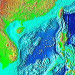
China will accelerate its pace of mapping the deep seabed, Zhang Jixian, president of the Chinese Academy of Surveying and Mapping, told China Daily. Unlike the electronic navigation chart released by the Chinese navy on Aug 25...
